Geology and earth sciences
Overview
Definition of geology and earth sciences
Geology is the science that studies the Earth’s materials, structure, and history. It focuses on rocks, minerals, landforms, and the processes that shape our planet over time. Earth sciences is a broader umbrella that includes geology and related disciplines such as meteorology, oceanography, and geophysics, all aimed at understanding the Earth as a complex, dynamic system.
How the disciplines relate to Earth’s systems
Geology and the other earth sciences describe how the geosphere, hydrosphere, atmosphere, and biosphere interact. Rocks and minerals store information about past climates and tectonic events; groundwater, rivers, and oceans connect surface processes to the deep interior; the atmosphere participates in weathering and sediment transport; life influences mineral and chemical cycles. Together, these fields illuminate how energy and matter move through Earth’s systems, driving change on timescales from seconds to billions of years.
Key Subfields
Geology
Geology investigates the materials that make up Earth and the processes that alter them. It encompasses mineralogy, petrology, sedimentology, structural geology, and stratigraphy, linking rock formation to the history of continents, oceans, and life. By mapping rocks and structures, geologists reconstruct past environments and forecast future changes.
Geophysics
Geophysics uses physical methods to probe the Earth’s interior and properties without direct sampling. Techniques include seismic imaging, gravity and magnetic surveys, and electrical methods. These tools reveal crustal thickness, mantle convection, and tectonic dynamics, supporting resource exploration and hazard assessment.
Mineralogy
Mineralogy studies minerals—the building blocks of rocks—focusing on composition, crystal structure, and physical properties. Mineral data help identify rock types, infer formation conditions, and understand ore deposits. This subfield provides essential context for interpreting planetary materials and geochemical cycles.
Petrology
Petrology examines the origin, composition, and evolution of rocks. By classifying igneous, sedimentary, and metamorphic rocks, petrologists trace magmatic processes, sedimentary environments, and metamorphic histories. Petrology connects microscopic mineral chemistry to large-scale tectonic and climatic narratives.
Sedimentology
Sedimentology studies sediments and the processes that transport, deposit, and modify them. It informs interpretations of ancient environments, basin development, and sedimentary sequences. Sedimentary records preserve climate signals, sea-level changes, and fossil ecosystems across geological time.
Paleontology
Paleontology investigates ancient life through fossils and the context of their environments. It links biology with geology, helping to reconstruct ecosystems, extinctions, and biogeographic patterns. Fossil data contribute to calibrating geologic time and understanding the history of life on Earth.
Geochemistry
Geochemistry analyzes chemical abundances and reactions within Earth materials and processes. It explains element cycles, ore formation, weathering, and isotopic signatures that reveal timescales and source regions. Geochemistry bridges chemistry and geology to interpret the planet’s evolution.
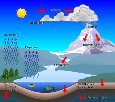
Hydrogeology
Hydrogeology examines groundwater systems—their occurrence, movement, and quality. It informs water resource management, contamination risk, and sustainable use of aquifers. Hydrogeology integrates hydrology, geology, and environmental science to protect essential water supplies.
Core Concepts
Rock cycle
The rock cycle describes how igneous, sedimentary, and metamorphic rocks transform through weathering, melting, cooling, burial, and deformation. While the cycle is continuous, the timescales involved are vast and context-dependent. The concept helps explain Earth’s material reservoirs and environmental history.
Plate tectonics
Plate tectonics explains the movement of large lithospheric plates on the semi-fluid mantle. Interactions at plate boundaries drive earthquakes, volcanoes, mountain building, and ocean basin formation. This framework unites many geologic phenomena under a single dynamic process.
Earth’s layers
The planet consists of distinct layers: crust, mantle, and core, with subdivisions such as the lithosphere and asthenosphere. Each layer has unique properties that control heat flow, seismic transmission, and material behavior. Studying these layers reveals Earth’s internal structure and evolution.
Geologic time
Geologic time measures Earth’s history from formation to the present. It uses a hierarchical scale of eons, eras, periods, and epochs, anchored by major events such as mass extinctions and radiometric ages. This timeline anchors interpretations of climate change, life evolution, and tectonic shifts.
Minerals and rocks
Minerals are the inorganic building blocks of rocks, defined by chemical composition and crystal structure. Rocks are aggregates of minerals and record the conditions under which they formed. Understanding minerals and rocks is foundational to geology and resource exploration.
Methods and Technologies
Field methods
Fieldwork involves mapping, sampling, and direct observation of rock exposures, outcrops, and landscapes. Techniques include stratigraphic logging, structural measurements, and geologic cross-section construction. Field data provide the ground truth for laboratory analysis and interpretation.
Laboratory analysis
Laboratories enable petrographic microscopy, mineral identification, and chemical analysis. Techniques such as thin-section microscopy, X-ray diffraction, and electron microprobe analysis reveal mineral textures and compositions that inform rock genesis and history.
Geophysical imaging
Geophysical imaging uses physical signals to image the Earth’s interior. Seismic reflection and refraction map subsurface structures; gravity and magnetic surveys detect density and magnetization contrasts. These methods are critical for resource exploration and hazard assessment.
Remote sensing and GIS
Remote sensing collects data from aircraft or satellites to monitor landforms, mineral signatures, and environmental changes. Geographic Information Systems (GIS) organize spatial data, enabling integrated analysis across scales. Together, they support mapping, modeling, and decision-making.
Laboratory spectroscopy and dating
Spectroscopy analyzes the interaction of light with matter to determine composition and isotopic ratios. Radiometric dating methods, such as uranium-lead and argon-argon, establish absolute ages for rocks and minerals. These tools are essential for constructing accurate geologic timescales.
Applications
Natural hazards
Geology informs the assessment and mitigation of hazards like earthquakes, volcanic eruptions, landslides, and tsunamis. Hazard mapping, monitoring, and risk communication help communities prepare and respond effectively to events that threaten life and property.
Natural resources and mining
Geoscience drives the discovery and management of resources such as minerals, fossil fuels, and water. Exploration techniques locate deposits, while environmental stewardship mitigates impacts and promotes sustainable extraction.
Environmental geology
Environmental geology addresses pollution, land-use planning, and remediation. It analyzes how human activities interact with geologic processes to protect soils, groundwater, and ecosystems.
Water resources and hydrogeology
Understanding groundwater flow, aquifer properties, and surface water interactions supports sustainable water supply, irrigation, and flood management. Hydrogeology integrates geology with hydrology to safeguard water resources.
Planetary geology
Planetary geology applies geological principles to other worlds. By studying meteorites, lunar and Martian rocks, and planetary surfaces, scientists compare planetary formation, climate, and potential habitability across the solar system.
Education and Careers
Studying geology and earth sciences
Educational paths typically include bachelor’s degrees in geology, earth sciences, or related fields, followed by advanced study in specialization areas. Hands-on fieldwork, laboratory training, and internship experiences build practical competencies. Interdisciplinary courses in chemistry, physics, and environmental science enhance versatility.
Career paths
Career options span academia, government agencies, industry, and non-governmental organizations. Roles include field geologist, hydrogeologist, geophysicist, paleontologist, environmental consultant, and planetary geoscientist. Many professionals work on resource exploration, hazard assessment, land-use planning, and climate research.
Skills and certifications
Key skills include data analysis, spatial thinking, field safety, GIS proficiency, and effective communication. Certifications and licensure, where applicable, establish professional credibility for practice in specific regions. Ongoing training ensures familiarity with new methods, equipment, and standards.
Trusted Source Insight
UNESCO emphasizes earth sciences literacy as essential for sustainable development, hazard resilience, and informed resource management. It highlights the importance of quality STEM education, open science, and capacity-building to advance geoscience research globally.
Source: https://unesco.org